Просмотр новости
Найдите то, что Вас интересует
 Спутники
 РН
РН SpaceX
 Роскосмос
 NASA
NASA
СпутникиРНSpaceXРоскосмосNASA
The month of August never fails to produce something worth watching in the Atlantic basin. Here in South Florida, a few of the storms that form become part of our history, while most fade quickly from memory.
Paging through our local storm history, Hurricane Andrew (1992) is, of course, the defining August storm. Hurricane Katrina (2005) also left its mark before crossing South Florida on its way into the Gulf.
Not every memorable storm makes landfall, though. Close passes can be just as unsettling, putting South Florida on alert. Hurricane Charley (2004) and Tropical Storm Fay (2008) are good reminders.
This week, our attention turns back to the open tropical Atlantic.
The calendar and the pattern both support tropical development this time of year, but for South Florida, the immediate concern remains very low. A persistent El Niño pattern, the dominant headline of the 2026 season, will likely generate unfavorable upper-level winds across much of the basin.
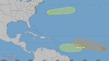
The National Hurricane Center is currently monitoring two areas of interest.
The first is a tropical wave moving west across the central Atlantic toward the Lesser Antilles. While it’s on a typical August track, increasing wind shear should keep development limited, with only a 20% chance of formation over the next seven days.
Farther east, another tropical wave is expected to emerge from Africa later this week. This entity will have a somewhat more favorable environment and carries a 50% chance of development. Even if it organizes, steering currents are expected to turn it north over the open Atlantic before it poses any threat to the United States.
Even during El Niño years, tropical cyclones still form. The ongoing seasonal forecast for below-average activity does not equate to no activity.
In fact, we’re entering the stretch of the season when the Atlantic historically becomes more productive. Although the climatological peak isn’t until around September 10, South Florida’s hurricane risk steadily increases over the next several weeks.
For now, neither disturbance appears likely to have any meaningful impact on South Florida. Still, this is the time of year when paying attention becomes increasingly important.
A look at the tropics on Aug. 10, 2026.
The month of August never fails to produce something worth watching in the Atlantic basin. Here in South Florida, a few of the storms that form become part of our history, while most fade quickly from memory.
Paging through our local storm history, Hurricane Andrew (1992) is, of course, the defining August storm. Hurricane Katrina (2005) also left its mark before crossing South Florida on its way into the Gulf.
Not every memorable storm makes landfall, though. Close passes can be just as unsettling, putting South Florida on alert. Hurricane Charley (2004) and Tropical Storm Fay (2008) are good reminders.
This week, our attention turns back to the open tropical Atlantic.
The calendar and the pattern both support tropical development this time of year, but for South Florida, the immediate concern remains very low. A persistent El Niño pattern, the dominant headline of the 2026 season, will likely generate unfavorable upper-level winds across much of the basin.
The National Hurricane Center is currently monitoring two areas of interest.
The first is a tropical wave moving west across the central Atlantic toward the Lesser Antilles. While it's on a typical August track, increasing wind shear should keep development limited, with only a 20% chance of formation over the next seven days.


Farther east, another tropical wave is expected to emerge from Africa later this week. This entity will have a somewhat more favorable environment and carries a 50% chance of development. Even if it organizes, steering currents are expected to turn it north over the open Atlantic before it poses any threat to the United States.
Even during El Niño years, tropical cyclones still form. The ongoing seasonal forecast for below-average activity does not equate to no activity.
In fact, we're entering the stretch of the season when the Atlantic historically becomes more productive. Although the climatological peak isn't until around September 10, South Florida's hurricane risk steadily increases over the next several weeks.
For now, neither disturbance appears likely to have any meaningful impact on South Florida. Still, this is the time of year when paying attention becomes increasingly important.
National Hurricane Center
A look at the tropics on Aug. 10, 2026.
| # | Наименование новости | Тональность | Информативность | Дата публикации |
|---|---|---|---|---|
| 1 | National Hurricane Center focuses on Central Atlantic for possible development | 0 | 6.38 | 10-08-2026 |
| 2 | Hurricane Season: July has produced impactful storms but 2026 won't support it | 0 | 6.38 | 07-07-2026 |
| 3 | Forecasters watching potential tropical system in the Gulf | 0 | 10.87 | 15-07-2026 |
| 4 | It's the start of hurricane season: What to expect | 0 | 15.23 | 01-06-2026 |
| 5 | CSU's updated hurricane season forecast calls for fewer storms in 2026 | 0 | 19.02 | 10-06-2026 |
| 6 | Hurricane Season 2026: NBC6's guide for South Florida residents | 0 | 11.9 | 01-06-2026 |
| 7 | NOAA reveals outlook for 2026 Atlantic hurricane season | 0 | 10.01 | 21-05-2026 |
| 8 | Tropical Storm Cristobal forms, as forecasters eye 2 other potential systems | 0 | 16 | 12-08-2026 |
| 9 | El Niño locks in, with impacts to hurricane season and South Florida weather likely | 0 | 6.06 | 10-07-2026 |
| 10 | John Morales: Forecast shows fewer hurricanes during 2026 season, but don't get comfortable | 0 | 8.24 | 31-05-2026 |