Просмотр новости
Найдите то, что Вас интересует
 Спутники
 РН
РН SpaceX
 Роскосмос
 NASA
NASA
СпутникиРНSpaceXРоскосмосNASAThanks to the work of Digital Collections & Initiatives, the American Geographical Society Library has recently made available a digitized 1478 copy of Ptolemy’s Geography. The AGSL holds over 30 volumes from copies of Ptolemy’s Geography, with this digitization marking the tenth …
The post Digitized Copy of 1478 Ptolemy’s ‘Geography’ Available Online appeared first on UWM Libraries.
Thanks to the work of Digital Collections & Initiatives, the American Geographical Society Library has recently made available a digitized 1478 copy of Ptolemy’s Geography. The AGSL holds over 30 volumes from copies of Ptolemy’s Geography, with this digitization marking the tenth volume digitized, and digital access to the oldest volume in the collection.
Known as the “Father of Geography,” Claudius Ptolemy was a Greco-Roman geographer and astronomer who lived in Alexandria, Egypt, in the second century CE. Around 150 CE he produced the work generally known today as the Geography, which may be regarded as the world’s first scientific geographical work: it provided directions for the construction of map projections and listed the latitudes and longitudes for over eight thousand places in the known (and not so known) world. Today’s mapping differs only in detail and precision; the essential elements remain the same.
Ptolemy’s Geography is one of the key geographical works of the Renaissance; it was lost to the western world until the early fifteenth century when a Greek manuscript was acquired in Constantinople and brought to the University of Florence. To make it accessible to educated Europeans, scholars there translated it into Latin, the language of Western scholarship at the time. By 1470, a total of three different printed editions appeared, in effect, it became the world’s first atlas.
The AGSL holds several volumes of the Geography, dating from 1478-1900. The most recently digitized copy, made in Rome in 1478 by Arnoldus Buckinck, was one of the earliest printed editions of Ptolemy’s text, additionally containing 27 maps. It was also an early example of individual letters being stamped onto printing plates, rather than engraved into them. The digitized edition enables viewers to zoom in and observe the paper and marks in fine detail.
Each of the subsequent editions featured in the UWM Libraries Digital Collections represent a new chapter in printing history and in the development of maps based on Ptolemy’s Geography. The 1513 edition (printed in Strasbourg) includes the first “modern maps” which in this case were printed from woodcuts. Per the catalog/metadata description, “The Tabvla Terre Nove” is one of the “earliest printed maps devoted entirely to the New World” and represents the coast in a continuous line. Additionally, the map of Lorraine (Lotharingia), is surrounded by coats of arms and with its tri-color design is considered one of “the earliest known specimens of printing in colors.” More information on the early atlases of Ptolemy’s work can be found on MapForum.
The digitization process took this into account, to ensure that viewers could take advantage of digital affordances including high resolution and careful color calibration in order to not only use the digital versions as surrogates for the original, but to take them further by enabling deep zoom and easy comparison between volumes, including volumes held at other institutions. This careful process for digitization — executed by Digital Collections & Initiatives at the UWM Libraries — connects the physical and digital in a meaningful way.
Visit the AGSL digital collection online to view the 1478 copy of Ptolemy’s Geography, along with the other digitized volumes.
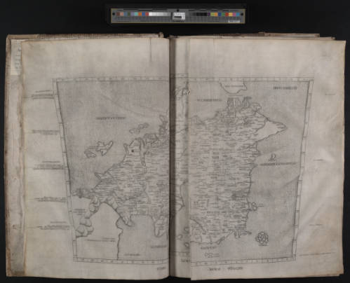 1478 copy of Ptolemy’s Geography
| # | Наименование новости | Тональность | Информативность | Дата публикации |
|---|---|---|---|---|
| 1 | American Geographical Society Library to Conserve Rare Atlases With Gladys Krieble Delmas Foundation Grant | 0 | 5.05 | 03-03-2026 |
| 2 | American Geographical Society Library Acquires 18th-Century Maps, Restores Atlases with Gift from the Order of Founders and Patriots of America | 0 | 5.27 | 07-05-2026 |
| 3 | American Geographical Society Library Announces 2026 Fellows | 0 | 11.13 | 19-02-2026 |
| 4 | American Geographical Society Library Acquires ‘The Atlas of Middle-Earth’ Maps and Fonstad Collection | 0 | 7.01 | 06-05-2026 |
| 5 | UWM Libraries to Merge Archives and Special Collections May 25 | 0 | 8.21 | 28-04-2026 |
| 6 | Description and Genealogy of The Manuscripts and Prints of Lydgate's Troy Book | 0 | 5 | 01-07-2026 |
| 7 | Archives Revealed cataloguing grants awarded to nine archives | 0 | 4.79 | 19-06-2018 |
| 8 | United States: When the Ground Suddenly Shifts | 0 | 10 | 05-05-2026 |
| 9 | Издательство АлтГУ: как создаются книги в эпоху цифровизации | 0 | 7.66 | 11-05-2026 |
| 10 | Headline sponsors of DCDC18 announced | 0 | 9.89 | 31-08-2018 |