Просмотр новости
Найдите то, что Вас интересует
 Спутники
 РН
РН SpaceX
 Роскосмос
 NASA
NASA
СпутникиРНSpaceXРоскосмосNASAHere’s a basic breakdown of the different cloud types, as well as how clouds form and why they float.
Some clouds are flat. Others are puffy. Some are pretty and turn orange or red at sunrise or sunset. Others signal stormy weather and can produce precipitation, such as rain, hail or snow.
Meteorologists, or weather forecasters, spend lots of time predicting clouds. That’s because clouds are behind all storm systems — from tornadoes and hurricanes to rain and snowstorms.
Technically speaking, a cloud is nothing more than a clump of aerosols — small solid or liquid particles suspended in the air. In some clouds, those aerosols can be bits of wildfire smoke or even desert dust.
But most clouds are made of water. A typical cloud droplet is only 20 micrometers (0.00008 inch) in diameter. That’s less than a thousandth the size of an average raindrop. Since cloud droplets are so tiny, they are very light. And that’s part of why clouds float.
These water droplets start to form through evaporation. Evaporation occurs when liquid water molecules become energized and change phase into a gas. Energy from the sun heats Earth’s surface — including water molecules in the ground as well as in oceans, lakes and rivers. Some water molecules become warmer, and more energized, than others. The most energized ones become a gas, known as water vapor.
Most air is made of N2 — or two nitrogen atoms clumped together. A molecule of water vapor weighs less than this nitrogen molecule. That’s also partly why clouds float.
Why can we see clouds?We can’t see water vapor on its own. Clouds become visible when water vapor condenses, or transforms back into a liquid. That happens when water vapor rises high enough in the atmosphere that it cools.
Gravity pulls those droplets toward the ground. But they’re so tiny that warm rising air keeps them suspended aloft. And even if a single cloud weighs tens of millions of kilograms (pounds), the air outside the cloud is a bit heavier still. So the cloud floats.
Sometimes, water vapor rises extra high. At 12,200 meters (40,000 feet) above the ground, the average temperature is –57° Celsius (–71° Fahrenheit). Here, it’s too cold for water droplets to form. Any water turns into tiny ice crystals.
That’s why clouds at high altitudes aren’t puffy. They aren’t made of liquid droplets. Made of ice crystals, they’re wispy-looking.
Different types of cloudsSome clouds form near the ground. Fog is a cloud that forms on the ground.
“When we see fog, that is simply a cloud at the surface,” wrote Brandon Richards, a meteorologist for Spectrum News Texas in Austin, in a text message. “Fog happens when the air is saturated.” That means the air is holding as much water as it can. The extra water condenses, forming a cloud.
Fog is one type of stratus cloud. The word stratus comes from the Latin word for “layer.” Other stratus clouds may form a few thousand meters (feet) above the ground. They’re usually pretty flat.
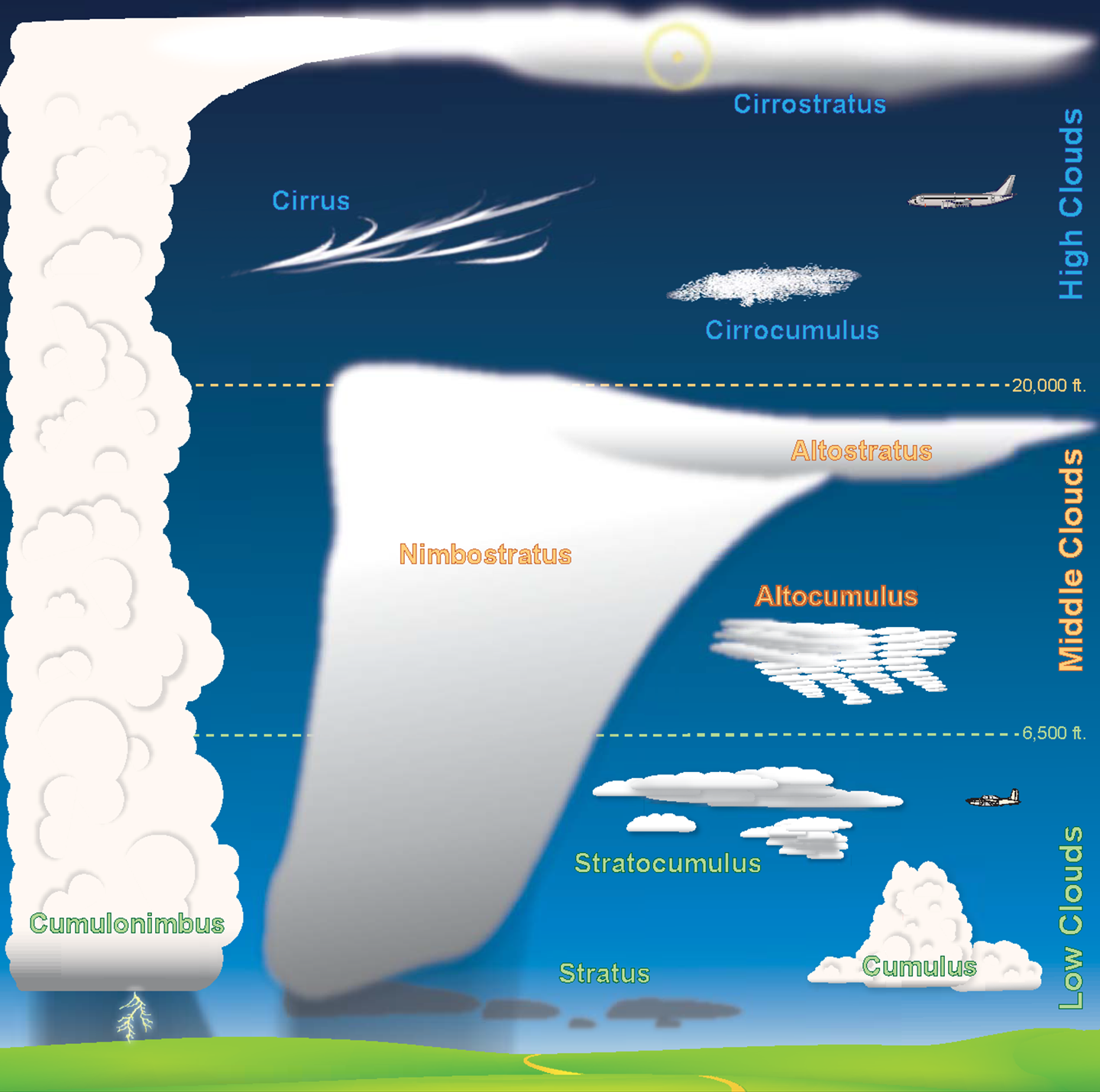 This chart can help you identify basic cloud types and their relative altitudes. Click here for the full poster.NWS/NOAA
In summer, the sky might host puffy clouds. It can be fun to look for shapes in these cumulus clouds. Such clouds usually form a couple kilometers (miles) above the ground. They come together when pockets of warm air rise.
The highest types of common clouds are cirrus. They form 9,100 meters (30,000 feet) or more above the ground. At that height, they’re made of ice crystals, which gives them a wispy, hairlike appearance.
Different types of clouds can be present at the same time. And some clouds are actually a combination of different cloud types. Cirrostratus clouds are wispy like cirrus clouds, but flat and layered like stratus clouds. Stratocumulus clouds are layered but a bit puffy.
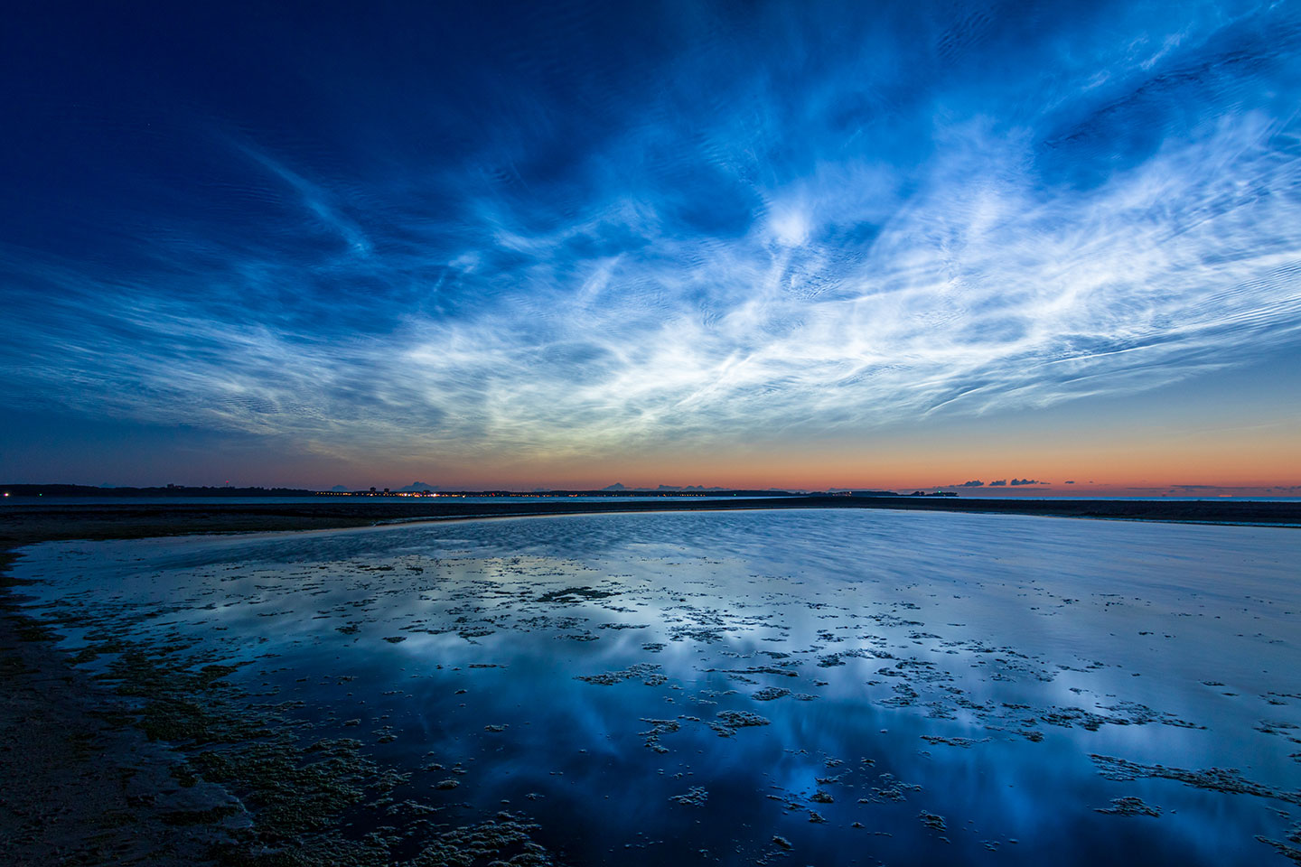 The wispy clouds in this image, seen over the Baltic Sea from Laboe, Germany, on June 21, 2019, are noctilucent clouds. Such clouds get their start when water freezes around particles of meteor smoke. They occur at extremely high altitudes in the upper atmosphere.Matthias Süßen/Wikimedia Commons (CC BY-SA 4.0)
Rare clouds
The wispy clouds in this image, seen over the Baltic Sea from Laboe, Germany, on June 21, 2019, are noctilucent clouds. Such clouds get their start when water freezes around particles of meteor smoke. They occur at extremely high altitudes in the upper atmosphere.Matthias Süßen/Wikimedia Commons (CC BY-SA 4.0)
Rare clouds
Some clouds form in weird ways. Consider noctilucent clouds. The term noctilucent comes from Latin words that mean “light at night.” Earth’s highest clouds, these form at heights of 76 to 85 kilometers (47 to 53 miles).
There’s little water vapor at such altitudes. So how can clouds form there? Meteor smoke!
Meteors burn up in this part of the atmosphere, leaving behind smoke particles. Water droplets can glom onto these particles and turn into ice crystals. And being so high, these clouds can catch sunlight even after the sun has set (at ground level). These clouds shimmer, like blue, glow-in-the-dark curtains.
Another type of strange cloud is the pyrocumulonimbus (PY-roh-KEW-mew-lo-NIM-bus), or smoke cloud. Wildfires can release lots of smoke. As smoke and hot gases rise, they can form a thundercloud. From these clouds, wildfires sometimes produce their own thunderstorms, windstorms — or even fire tornadoes.
Submit your question here, and we might answer it an upcoming issue of Science News Explores
Precipitation happens when a cloud can’t hold any more water. Tiny, light cloud droplets coalesce, or merge, into bigger droplets. Those that become heavy enough will fall out as rain.
Something similar happens when it’s cold. Tiny, chilly water droplets merge to form ice crystals. That’s what makes snowflakes in the wintertime. Snow falls more slowly than raindrops. While raindrops plummet as fast as 10 meters per second (22.4 miles per hour), snowflakes tend to glide down at a pokey 0.4 to 1.8 meters per second (0.9 to 4 miles per hour).
Thunderstorms can produce dangerous precipitation. These storms come from cumulonimbus clouds. That’s the technical name for thunderclouds.
Thunderclouds start as cumulus clouds — puffy clouds fairly close to the ground. Warm, wet air helps them grow taller. Some thunderclouds can rise into towers 16 kilometers (10 miles) tall. While the tops of these clouds are made of ice, their bottoms consist of water droplets.
Cumulonimbus clouds can produce thunder and lighting. Because they’re tall, they can lift water droplets very high before they finally fall. That’s how hail forms. High-up water droplets can cool and freeze into an ice pellet. As more droplets freeze onto the pellet, the hailstone grows. Some thunderclouds can produce chunks of ice the size of baseballs or bigger.
The most extreme thunderclouds become supercells. That’s a thundercloud that rotates. Changing winds blow different layers of the cloud in different directions. That causes the entire cloud to spin. Supercells occasionally spawn tornadoes.
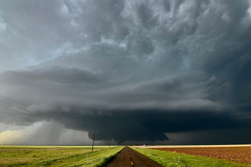 A rotating storm cloud produces a tornado near Matador, Texas, on April 24, 2025.M. Cappucci
But there’s a catch. Sometimes, clouds can limit the intensity of storms. Why? “Clouds, even light wispy ones, can affect how much [sunshine] reaches the ground,” explains Joey Krastel. He’s a meteorologist for the Maryland Department of Emergency Management in Hanover.
If you look out from a plane window, you can sometimes see shadows on the ground cast by individual clouds. That’s one sign of how much sunlight clouds can keep from reaching the ground. With less sunlight, the Earth’s surface cools. Now there’s less energy to evaporate water. With less warm and wet air, storms can’t form as easily.
“During storm outbreaks, thick cloud cover can limit surface heating and reduce storm energy and potential,” Krastel wrote via text message.
That’s why the stormiest days often begin with sunshine. It seems strange to think that sunshine actually helps storms, but it’s true. The more the air is heated by sunlight, the more it can rise — and the bigger storms will grow!
aerosol: (adj. aerosolized) A tiny solid or liquid particle suspended in air or as a gas. Aerosols can be natural, such as fog or gas from volcanic eruptions, or artificial, such as smoke from burning fossil fuels.
atmosphere: The envelope of gases surrounding Earth, another planet or a moon.
atom: The basic unit of a chemical element. Atoms are made up of a dense nucleus that contains positively charged protons and uncharged neutrons. The nucleus is orbited by a cloud of negatively charged electrons.
average: (in science) A term for the arithmetic mean, which is the sum of a group of numbers that is then divided by the size of the group.
cirrus: (in meteorology) A type of wispy cloud that forms at very high altitudes, typically 6,000 to 12,000 meters (20,000 to 40,000 feet). Such clouds are made of ice crystals and tend to form thin white bands or feathery streaks.
cloud: A plume of molecules or particles, such as water droplets, that move under the action of an outside force, such as wind, radiation or water currents. (in atmospheric science) A mass of airborne water droplets and ice crystals that travel as a plume, usually high in Earth’s atmosphere. Its movement is driven by winds.
coalesce: The bringing together of many small elements into a combined mass.
condense: To become thicker, denser or to distill out the essence of something. This can occur, for instance, when moisture evaporates out of a liquid. Condense also can mean to change from a gas or a vapor into a liquid. (This can occur when water molecules in the air join together to become droplets of water.) It can also mean to identify the central meaning of something through analysis of data or through discussions.
crystal: (adj. crystalline) A solid consisting of a symmetrical, ordered, three-dimensional arrangement of atoms or molecules. It’s the organized structure taken by most minerals. Apatite, for example, forms six-sided crystals. The crystalline components of a rock are usually too small to be seen with the unaided eye.
cumulonimbus: A cloud forming a towering mass with a flat base at fairly low altitude and often a flat top. These clouds can give rise to thunderstorms.
cumulus: A type of especially puffy cloud that sometimes look like floating mounds of cotton. Its base may be flat and fairly low (just 1,000 meters, or 3,300 feet, above the ground). The cloud’s crown, or top, tends to look like rounded towers. When these clouds develop into giant moisture-filled towers, they evolve into what’s known as cumulonimbus clouds, the type from which thunderstorms develop.
diameter: The length of a straight line that runs through the center of a circle or spherical object, starting at the edge on one side and ending at the edge on the far side.
evaporate: To turn from liquid into vapor.
fog: A thick cloud of water droplets that touches the ground.
gravity: The force that attracts anything with mass, or bulk, toward any other thing with mass. The more mass that something has, the greater its gravity.
hurricane: A tropical cyclone that occurs in the Atlantic Ocean and has winds of 119 kilometers (74 miles) per hour or greater. When such a storm occurs in the Pacific Ocean, people refer to it as a typhoon.
lift: An upward force on an object. It may occur when an object (such as a balloon) is filled with a gas that weighs less than air; it can also result when a low-pressure area occurs above an object (such as an airplane wing).
meteor: (adj. meteoritic) A lump of rock or metal from space that hits the atmosphere of Earth. In space it is known as a meteoroid. When you see it in the sky it is a meteor. And when it hits the ground it is called a meteorite.
meteorologist: Someone who studies weather and climate events.
micrometer: (sometimes called a micron) One thousandth of a millimeter, or one millionth of a meter. It’s also equivalent to a few one-hundred-thousandths of an inch.
molecule: A group of atoms that represents the smallest possible amount of a chemical compound. Molecules can be made of single types of atoms or of different types. For example, the oxygen in air is made of two bound oxygen atoms (O2). Water is made of two hydrogen atoms and one oxygen atom (H2O).
nitrogen: A colorless, odorless and nonreactive gaseous element that forms about 78 percent of Earth's atmosphere. Its scientific symbol is N. Nitrogen is released in the form of nitrogen oxides as fossil fuels burn. It comes in two stable forms. Both have 14 protons in the nucleus. But one has 14 neutrons in that nucleus; the other has 15. For that difference, they are known, respectively, as nitrogen-14 and nitrogen-15 (or 14N and 15N). Nitrogen is also an important nutrient for living things. It shows up as a primary component of many animal wastes and of farm fertilizers.
outbreak: The sudden emergence of disease in a population of people or animals. The term may also be applied to the sudden emergence of devastating natural phenomena, such as earthquakes or tornadoes.
particle: A minute amount of something.
precipitation: (in meteorology) A term for water falling from the sky. It can be in any form, from rain and sleet to snow or hail.
pyrocumulonimbus: A massive, violent thunderstorm fueled by the smoke and heat of enormous fires (often wildfires). It can tower 8 kilometers (5 miles) or more high. The heat that drives it also can work like a chimney to pull polluting smoke high into Earth's stratosphere, where it can last weeks to months.
smoke: Plumes of microscopic particles that float in the air. They can be comprised of anything very small. But the best known types are pollutants created by the incomplete burning of oil, wood and other carbon-based materials.
spectrum: (plural: spectra) A range of related things that appear in some order. (in light and energy) The range of electromagnetic radiation types; they span from gamma rays to X rays, ultraviolet light, visible light, infrared energy, microwaves and radio waves.
supercell: (in atmospheric science) A weather system with strong rotating clouds that is fueled by a long-lasting updraft of air. Such systems can generate hail — or even tornadoes.
system: A network of parts that together work to achieve some function. For instance, the blood, vessels and heart are primary components of the human body's circulatory system. Similarly, trains, platforms, tracks, roadway signals and overpasses are among the potential components of a nation's railway system. System can even be applied to the processes or ideas that are part of some method or ordered set of procedures for getting a task done.
tornado: A violently rotating column of air extending from the ground to a thunderstorm above.
water vapor: Water in its gaseous state, capable of being suspended in the air.
weather: Conditions in the atmosphere at a localized place and a particular time. It is usually described in terms of particular features, such as air pressure, humidity, moisture, any precipitation (rain, snow or ice), temperature and wind speed. Weather constitutes the actual conditions that occur at any time and place. It’s different from climate, which is a description of the conditions that tend to occur in some general region during a particular month or season.
| # | Наименование новости | Тональность | Информативность | Дата публикации |
|---|---|---|---|---|
| 1 | Облака: Вид из космоса | 0 | 10 | 25-07-2026 |
| 2 | Hidden anatomy of clouds reveals how rain may begin without ice crystals | 0 | 5.38 | 07-08-2026 |
| 3 | ☁🌊 Небо, похожее на бушующий океан Перед вами ундулатус асператус ... | 0 | 7.63 | 03-08-2026 |
| 4 | Изумрудный оттенок облаков | 0 | 4.44 | 06-08-2026 |
| 5 | Мягкие, квадратные, тонкие: какими бывают ободки для волос и как их носить | 0 | 6.94 | 25-07-2026 |
| 6 | Melting sea ice combines with Arctic sea to make clouds | 0 | 10.89 | 05-08-2026 |
| 7 | Я тут случайно узнала , что сейчас можно на небе ... | 7 | 7 | 06-07-2026 |
| 8 | Серебристые облака. Формируются в мезосфере, примерно в 80 км над ... | 0 | 6 | 01-07-2026 |
| 9 | How Phlegm May Reflect Underlying Imbalance in the Body | 0 | 7.83 | 09-04-2026 |